Spartan Agoge
Level 6 Valued Member
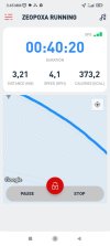
Hello everyone. I need to measure a certain distance I run. In google maps it is 3.8km.
Then I walked it, holding my phone, with a running app I downloaded. In the app it is 3.2km. The difference is huge.
It is important for me to know the distance, for my running times.
Does anyone have any idea which one is more accurate, google maps, or the app?
Thank you in advance.
Then I walked it, holding my phone, with a running app I downloaded. In the app it is 3.2km. The difference is huge.
It is important for me to know the distance, for my running times.
Does anyone have any idea which one is more accurate, google maps, or the app?
Thank you in advance.